Eleazur D. Davis, Samuel White, Martin Wilson - School Inspectors
Nehemiah Ingersoll - Poundmaster (caretaker of seized or lost livestock and other farm animals)
Eleazur D. Davis, Ichabod Hinckley, Jessemin Drake - Constables
In December of 1829, Samuel Laing had a blacksmith shop built (on a 7/10 acre lot) and began the business of shoeing horses, making tools and various hardware, repairing plows and wagons, and building, repairing wagon wheels. Next to his blacksmith shop, he built a brick building to house a store where he sold merchandise. The business, and later the building, was passed around until the last owner John Benton used it for onion storage. In 1974, the Genesee Country Museum gained ownership of the
building and relocated it to Mumford, NY.
Some of the other blacksmith shops that operated in Elba:
John Weber's blacksmith and wagon shop on Maple Avenue - opened December 1896.
James Gourley's blacksmith shop at Lancton Corners - opened in the 1850s.
There were about 10 blacksmith shops operating in Elba in the 1850s. Some of the blacksmiths were William Bradley, Caleb Wells, Ezeriah Wilson, Joshua Wicks, James Emery, Chauncey Hollister, William Dean, Gurley Dean, William Buckingham, Sylvanus Perry, Richard Carl, and Solomon Hill.
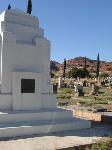
Solomon Hill was the most notable, as he was a Revolutionary War veteran that lived to be 104 years old. He moved to Elba some time after the war and died in 1857. Since he had no known relatives in the region, he was buried in an unmarked grave, That is, until 1880 when Sunday School children started a collection to give the Revolutionary War veteran a proper tombstone. He is buried in the
Pine Hill Cemetery in Elba.
- - -
The earliest cobbler and bootmaker in the area was J. Emery, who opened his business around 1824 at Daw's Corners. By 1850, there were 13 shoemakers in Elba.
Some of the earliest cooperage shops in Elba were those owned by the Staples family, Genesee Manufacturing Company, A.A. Grinnell, and French & Rugg Company.
Benson B. French and William Rugg also owned a lumber company and had operated since before 1871. Their business was located north of the village of Elba.
Staples & Butterworth owned a lumber company that began operation before 1870.
A.A. Grinnell purchased Staples' business in 1902.
- - -
Some early mercantile shops and stores in Elba include:
A man named Mr. Raymond opened one in 1831 on 1 North Main Street. The original building was destroyed by fire in 1869 and was rebuilt. The rebuilt building still stands today.
The building on 3 North Main Street was a mercantile starting sometime in the 1880s and under the ownership of Milton Conner and William Brailey. This building also still stands today.
The 5th Main Street mercantile was owned by a man named Hundredmark and was built in 1881. The building burned down in 1931.
At 7th Main Street, this mercantile had its roots in a millinery run by Mrs. Emma Brown and Miss Mary A. Caple. They opened their business in 1880 and other business also began to operate in the building Which included a drug store, grocery store, and a bakery. This building still stands.
10 Main Street also got its start as a millinery and was a grocery store by the 1890s. The building was damaged in a fire on September 15th, 1903. Around 2 a.m., the fire was seen by a girl working at the Hotel Swartz and she set off the fire alarm. The
Batavia Fire Department
made their way to Elba after being told about the fire by telephone. The building was a complete loss and the lot was left empty until 1915 when the Elba Grange Meeting Hall was built.
11 North Main Street began operation under Tristam Brown as a hardware shop in January of 1878. It was also a grocery store and a restaurant at one time. Also, it may still be a restaurant.
Barton's Store, at 15 North Main Street, was owned by Elliot P. Barton. By 1969, he was in partnership with Stephen L. Maltby and they sold groceries at the store. The building, with various businesses housed in it, changed hands throughout the years. The building still stands today.
- - -
The Tornado Windmill Company was opened in 1874 by twenty-something year old brothers Frank E. Barr and Orin C. Barr. The business was quite successful but the Orin Barr's health problems, caused by his inflammatory rheumatism, caused him to 'retire' from the business. He died from complications from his rheumatism on December 22nd, 1880, at around the age of his early thirties. After the loss, Frank closed down their windmill business and found employment elsewhere. Frank caught mumps in 1889 and died on September 13th of that year, around age 40.
The Elba Creamery was opened in July of 1895 and began operations. The first day was very successful for the creamery but a drought soon hit the area and hurt the business. They survived though and the business successful for a while but they began to have more financial troubles over the few years. By 1910 the building was abandoned and sat vacant until a sawdust fire burned the building down. It was the fourth fire flare-up that was too much for the firemen to put out.


 , is not know to most. On the night of April 26, 1777, word got out that British troops were preparing to invade Danbury, Connecticut. The 16-year-old Ludington took off on horseback that and traveled first to Danbury to warn its citizens. From there, she continued on to alert the militiamen under her father's leadership. The whole trip was around 40 miles and more than twice the distance that Paul Revere had to travel on horseback.
 :
:
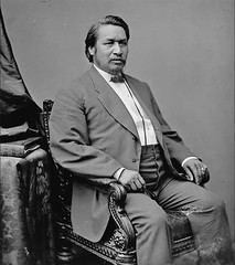
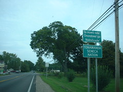
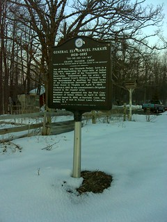
 tribe. Though Susquehannocks referred to themselves as Andastes. When the tribe settled at Conestoga, they gave up war and disagreeing members left the tribe and joined other tribes. Shikellamy was one of the individuals to leave the Andastes and joined up with the Oneida. He became a part of the Oquacho (Wolf Tribe). It's said that he rose quickly within the tribe and was a leader amongst the tribe. By the year of 1728, he was the representative of the Six Nations in dealings with the proprietary colonial government. He even became favorable amongst the English.
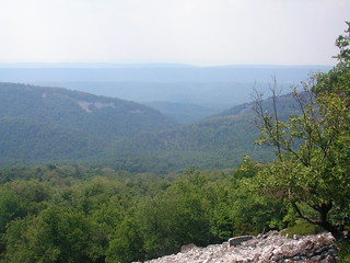
 and the
  . Furthermore, the trail is one section of the massive, 1,800 mile
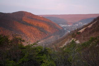

 , Buford's Massacre and the Waxhaws. It was a battle that occurred while the Revolutionary War was in full-swing, on May 29, 1780. The battle took place around the area of Lancaster, South Carolina. Abraham Buford was the leader of the Continental Army forces and Banastre Tarleton led the Loyalist forces. British officer Tarleton sent forward a demand for Buford and his forces to surrender and Buford refused. Tarleton's calvary attacked Buford's men and some of them began to surrender. There was a truce and Buford tried to surrender. That truce ended when a shot hit Tarleton's horse and Tarleton was trapped under his now dead horse. The shot caused the Loyalists and the accompanying British troops to begin an attack. This kept going as Tarleton was still trapped and had no control over his men. Continental soldiers, including those who previously surrendered, were attacked by the Brits. 113 Continental soldiers were killed with sabers, 150 other Continentals were severely injured and were left where they were, and 53 were taken as prisoners by the British forces.
 it was a wilderness over a large area and without development. Before settlers began the move into the area, the federal government pushed the Caddo Tribe off their lands which were at present-day Plain Dealing. In 1839, the federal government looked to profit off these lands (as they had done with seized lands elsewhere) and sold them to families. Many of whom didn't know the story of the area or how the lands were acquired by the federal government. One of the first families to arrive in the area were the Gilmers. It was George Oglethorpe Gilmer and his oldest son, James Blair Gilmer, that purchase the lands from the government. They bought thousands of acres of land along both sides of the Red River. George had also bought an additional 5,000 acres a few miles from their Red River lands.

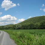
 a town best known for its mucklands, onion-growing, and farms, was developed by an act of NYS to divide Batavia. The act was passed on March 14th, 1820 and Elba became a town comprised of 38,000 acres. Back then, and before the second division on April 11th, 1842, Elba included what is now Oakfield. and today the town is 22,631 acres in size.
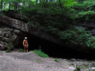
 , with an interesting history, is Tytoona Cave in Sinking Valley. It's one of the newer nature preserves in the region. It is officially known as the Tytoona Cave Nature Preserve and is owned by the
  chapter of the National Speleological Society after being bought on December 23, 1997 from the Western Pennsylvania Conservancy. The size of the preserve is around 7 acres.
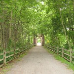
 , one of Pennsylvania’s best trails, offers visitors a chance to explore the natural beauty of the Pine Creek Gorge—often referred to as the “Grand Canyon of Pennsylvania.” Spanning 62 miles through Tioga and Lycoming Counties, this well-maintained trail is ideal for hiking, cycling, and wildlife observation, making it a must-visit for nature enthusiasts.


 will grow quickly and can reach heights of up to 80 feet. The average and expected height of most Catalpas will be around fifty feet. This tree grows the quickest during its first ten years, reaching about twenty feet tall before it slows down.
 tree has been known to be used as a medicine with its bark being boiled to make a tea. Other past uses of the trees leaves, flowers, bark, and roots were as a treatment for snake bites,

 , the Northern Catalpa, and the Southern Catalpa. The Catalpa tree also goes by the Indian bean tree, the cigar tree, and (historically) the Catawba.