

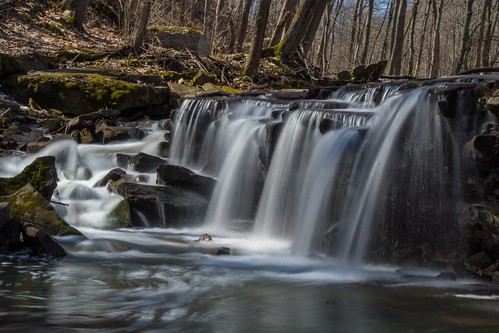
Features Indian Falls and numerous other natural sights.
The Rollin T. Grant Gulf Wilderness Park is a true, unspoiled wilderness. (Photo of sign at https://goo.gl/maps/4S67BVagrxP2) There are trails but little other accommodations of the modern life. The location is on the south side of West Jackson Street (near the 5900 block) where there is limited auto parking. Within the park is a millstone originally used in a 19th Century paper mill on the north side of the Erie Barge Canal
 in Lockport (at the present location of Upson Park). It was transported to this site in 1972 with a plaque attached to it to recognize the donation of seven acres at the park entry by the family of Josephine McCollum Carveth. The poem on the plaque reminds us to look here for English violets in early to mid April.
Map sign at the Park: https://goo.gl/maps/eowjXYDCVJF2
Overview and History
The melting ice left vast bodies of water in the lowland. Glacial Lake Iroquois, the larger predecessor of Lake Ontario
 , was one. Its beaches are today represented by the plateau to the north of the escarpment here at Lockport. In fact, U.S. Route 104 is built on the old beach ridge.
Glacial Lake Tonawanda lay to the south of Lockport between the Niagara Escarpment (goes through and divides Lockport) and the Onondaga Escarpment (which lies generally along Route 5 from the Buffalo city line through Amherst and Clarence--most dramatically noticed on Transit Road, heading north just past today's Eastern Hills Mall). The level plain between Lockport and Buffalo represents the bottom of Lake Tonawanda, with Tonawanda Creek being the remnant of the deepest part. Bear Ridge and Beach Ridge Roads were built along northerly dunes of the old lake.
Lake Tonawanda drained north into Lake Iroquois through outlet streams whose spillways eroded gorges through dolostone, shale, limestone, and sandstone strata. The largest spillway was at Lewiston on the Niagara River (which eventually migrated south, developing into Niagara Falls). The second-largest spillway was here at Lockport and the Gulf Ravine is the exact location of this spillway. The third largest spillway out of the lake was near the present Cold Springs Road and the Lockport Town & Country Club golf course. There were lesser spillways to the east, including Gasport's Royalton Ravine and yet another just east of Medina. There was a slight west tilt to which favored more lake water going to the west.
As the level of Glacial Lake Tonawanda fell, flow of the outlets ceased except for local drainage and the Niagara River at Niagara Falls. With a greater initial flow the spillway at Lewiston-Niagara Falls cut more rapidly down the cap rock than falls at Lockport and points east. Finally when Lake Tonawanda fell below the level of the spillways at Lockport and points east, the falls here just dried up. Niagara Falls became the only outlet for the remains of Lake Tonawanda and for the output of the other Great Lakes.
The Alabama and Oak Orchard Swamps to the east and south of Lockport, and the overflowing ditches and creeks along roads in Amherst and Tonawanda during spring thaws are evidence that "old Lake Tonawanda" may not be completely drained yet. The West Branch of 18-Mile Creek, flowing through our Gulf Park, is all that remains of an ancient torrential stream.
Rocks and Fossils
Proof of the age of rock strata in Gulf Wilderness Park is found in the red sandstone surfaces of the Grimsby sandstone, where structures like intertwined ropes ("Arthrophycus") represent the fossil remains of worm burrows from the Silurian Period of about 430 million years ago. Fossils are also found in other rock layers in this park. One can look for crinoids, brachiopods, and corals.
Just east of the park property, along West Jackson Street, you can encounter an excellent display or two major rock formations being cut through in this area and notice the different weathering effect on each. The top layer is the "Medina group" of sandstone, while layers of (red) shale below it are of the Queenston group. As the shale begins to crumble it takes a course of turning into stone debris and eventually clay. The results can be easily seen at this location.
This stone display is equivalent to what you'd find through the Gulf ravine. At the bottom of the ravine, where most of the nature trails are routed, you'll find Grimsby sandstone formations and limestone.
John Keryk, who has explored this area intensively over the years advises fossil hunters, "Park near or at where the nature park is off West Jackson Street and head up-stream. The outcrops best are near stream level. Can also park by RR tracks. That used to be a good area for weathered fossils from the Clinton formation (at least until they re-graded the RR right of way). Still, west side of tracks one can find good examples of Clinton formation lying on the ground." See the map at the bottom of this page.
Wildflowers
 , hepatica
 , and trillium
 . Later comes wild mint, leeks; then wild roses, jewelweed and doll's-eyes. Ferns are evident most of the year. In addition to the flowers, a wide variety of trees are found here.
Trees, Shrubs, & Vines
A wide variety of trees typical of the northeastern hardwood forest is found in Gulf Wilderness Park. Essential to the Gulf's life cycle are the many dead and dying trees. Birds, mammals, amphibians and reptiles are dependent in various ways on "snags" or standing dead trees. They are used for nesting, courting, mating, hibernating and as rich sources for foraging insects. Equally important are fallen logs that are essential for feeding, reproduction and protection. Fungi, algae and mosses thrive on the decaying wood.
Map Of Gulf Wilderness Park
Although you may enter Wilderness Park off of Niagara Street, near the railroad where the "parking" area is indicated on the map, the preferred entry for most will be off West Jackson Street. There are four separate nature trails through the park which are color-coded on a map at the entry points. The trails have no special individual significance except as reference points.
Friday, September 23, 2016
Tags :
Lockport
,
New York
,
Park
